Search
Filters
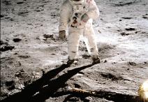
Apollo 11 Mission Commentary, Transcript, July 20, 1969
Apollo 11 Mission Commentary, Transcript, July 20, 1969
USAF Lunar Reference Mosaic LEM-1, 3rd Edition, July 1966
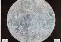
USAF Lunar Reference Mosaic LEM-1, 3rd Edition, July 1966
President John F. Kennedy’s Message to Congress, May 25, 1961
President John F. Kennedy’s Message to Congress, May 25, 1961
Amendment to H.R. 15279, Legislative, Executive, and Judicial Fiscal Year 1915 Appropriations Act, June 13, 1914
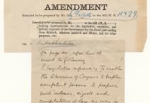
Amendment to H.R. 15279, Legislative, Executive, and Judicial Fiscal Year 1915 Appropriations Act, June 13, 1914
Division of agricultural fund between white and colored schools, 1892–93
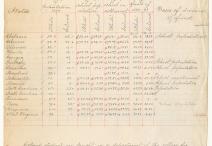
Division of agricultural fund between white and colored schools, 1892–93
Senator Justin S. Morrill of Vermont, photograph by the Brady-Handy Studio, ca. 1860
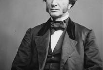
Senator Justin S. Morrill of Vermont, photograph by the Brady-Handy Studio, ca. 1860
S. 6219, A bill to provide for the inspection . . .of live cattle, sheep, and goats and . . . food products thereof, (Meat Inspection Act of 1906), May 21, 1906
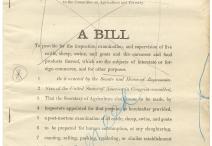
S. 6219, A bill to provide for the inspection . . .of live cattle, sheep, and goats and . . . food products thereof, (Meat Inspection Act of 1906), May 21, 1906
“The Meat Market,” color lithograph by Carl Hassmann, Puck, June 13, 1906
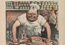
“The Meat Market,” color lithograph by Carl Hassmann, Puck, June 13, 1906
Cutting up the Hogs, Armour’s Great Packing House, Chicago, stereograph by Strohmeyer & Wyman, 1893
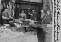
Cutting up the Hogs, Armour’s Great Packing House, Chicago, stereograph by Strohmeyer & Wyman, 1893