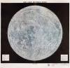
To prepare for landing a manned spacecraft on the moon, the National Aeronautics and Space Administration (NASA) explored the lunar surface remotely. This map of the moon’s earthside hemisphere, created by NASA and the Department of Defense, is a composite of photos taken by three observatories.
Geography and Map Division, Library of Congress
USAF Lunar Reference Mosaic LEM-1, 3rd Edition, July 1966
Sending Americans into Space
In the 1950s, the United States and the Soviet Union began programs for manned and unmanned scientific missions into space. The Soviets’ successful launch of the unmanned Sputnik 1 satellite in 1957 made Congress determined to jolt the U.S. space program into action. Winning the race to space became a political, scientific, and security priority. The United States intensified its efforts to be the first nation to send a man to the moon.
To prepare for landing a manned spacecraft on the moon, the National Aeronautics and Space Administration (NASA) explored the lunar surface remotely. This map of the moon’s earthside hemisphere, created by NASA and the Department of Defense, is a composite of photos taken by three observatories.
Geography and Map Division, Library of Congress