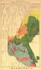
The atlas accompanying Tertiary History of the Grand Canõn presented both geological and topographical maps created by the U.S. Geological Survey. This map used color to distinguish zones related to geological eras spanning more than three billion years, from the Archaean to the Tertiary. Other colors identified types of volcanic rock that were clues to the area’s geological history.
Geography and Map Division, Library of Congress
“Geological Map of the Western Part of the Plateau Province,” map by the U.S. Geological Survey, Atlas to . . . the Tertiary History of the Grand Cañon District, 1882
Surveying the Grand Canyon
Created by an act of Congress in 1879 to map the western territories of the United States, the U.S. Geological Survey (USGS) issued its first publication—a report on the Grand Canyon—in 1882. The author, Clarence E. Dutton, a geologist and army officer, had begun surveying the rugged region of the Colorado Plateau as an associate of explorer John Wesley Powell in 1875. Dutton’s monograph on the Grand Canyon inaugurated a series of USGS studies of the geology, paleontology, and related aspects of the nation’s public lands.
Those who have long and carefully studied the Grand Canyon of the Colorado do not hesitate for a moment to pronounce it by far the most sublime of all earthly spectacles.
Clarence E. Dutton, Tertiary History of the Grand Cañon District with Atlas, 1882
The atlas accompanying Tertiary History of the Grand Canõn presented both geological and topographical maps created by the U.S. Geological Survey. This map used color to distinguish zones related to geological eras spanning more than three billion years, from the Archaean to the Tertiary. Other colors identified types of volcanic rock that were clues to the area’s geological history.
Geography and Map Division, Library of Congress