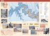
The U.S. Geological Survey continues its mission to provide accurate scientific information to Congress and the public. In 2000 cartographer George H. Billingsley created the first digital geological map of any part of the Grand Canyon. Produced in conjunction with the National Park Service, which manages the Grand Canyon, it was designed to serve park visitors and government agencies.
Courtesy of the U.S. Geological Survey
Geologic Map of the Grand Canyon . . . , Northwestern Arizona, map by George H. Billingsley for the U.S. Geological Survey, 2000
Surveying the Grand Canyon
Created by an act of Congress in 1879 to map the western territories of the United States, the U.S. Geological Survey (USGS) issued its first publication—a report on the Grand Canyon—in 1882. The author, Clarence E. Dutton, a geologist and army officer, had begun surveying the rugged region of the Colorado Plateau as an associate of explorer John Wesley Powell in 1875. Dutton’s monograph on the Grand Canyon inaugurated a series of USGS studies of the geology, paleontology, and related aspects of the nation’s public lands.
Those who have long and carefully studied the Grand Canyon of the Colorado do not hesitate for a moment to pronounce it by far the most sublime of all earthly spectacles.
Clarence E. Dutton, Tertiary History of the Grand Cañon District with Atlas, 1882
The U.S. Geological Survey continues its mission to provide accurate scientific information to Congress and the public. In 2000 cartographer George H. Billingsley created the first digital geological map of any part of the Grand Canyon. Produced in conjunction with the National Park Service, which manages the Grand Canyon, it was designed to serve park visitors and government agencies.
Courtesy of the U.S. Geological Survey