The U.S. Exploring Expedition surveyed the Pacific Ocean, mapping nearly 300 islands, including the Marianas and Fijis. It explored the coast of Australia, determined that Antarctica was a continent, and charted the northwest coast of North America. The voyage helped establish U.S. claims to the Oregon Territory, Antarctica, and Wake Island in the Pacific.
Records of the Hydrographic Office, National Archives and Records Administration
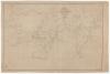
Chart of the World Shewing the Tracks of the U.S. Exploring Expedition, 1838–1842
Exploring the World
Throughout the 19th century Congress funded expeditions to explore land and sea. In 1836 Congress authorized the United States Exploring Expedition—also called the Wilkes Expedition after its leader, naval officer Charles Wilkes. Its purpose was to circumnavigate the world, promote commerce, and "extend the bounds of science and ... Knowledge." The four-year expedition mapped South Sea islands and Pacific coastlines, established trade, and gathered voluminous information that aided the United States in becoming a leading scientific and naval power.
The U.S. Exploring Expedition surveyed the Pacific Ocean, mapping nearly 300 islands, including the Marianas and Fijis. It explored the coast of Australia, determined that Antarctica was a continent, and charted the northwest coast of North America. The voyage helped establish U.S. claims to the Oregon Territory, Antarctica, and Wake Island in the Pacific.
Records of the Hydrographic Office, National Archives and Records Administration